| dc.creator | Benedetti, Ana Caroline Paim | |
| dc.date.accessioned | 2007-02-01 | |
| dc.date.available | 2007-02-01 | |
| dc.date.issued | 2006-01-30 | |
| dc.identifier.citation | BENEDETTI, Ana Caroline Paim. Spatial analisis of the land use and cover in the hydrographic subbasin of arroio arenal, Santa Maria/RS. 2006. 125 f. Dissertação (Mestrado em Recursos Florestais e Engenharia Florestal) - Universidade Federal de Santa Maria, Santa Maria, 2006. | por |
| dc.identifier.uri | http://repositorio.ufsm.br/handle/1/8684 | |
| dc.description.abstract | This work investigates the dynamics of the classes of land use and cover in the hydrographic subbasin of Arroio Arenal - RS, through the representation of spacetime processes. Spatial analysis of a distinct time series among the dates of October of 1995, May of 2000 and January of 2005 through a set of multisensor images was performed. It has generated representative landscape information and related them to different socioeconomic, politic and enviromental aspects inherent to the Subbasin in question. The spatial analysis starts from the LEGAL language implemented in a Geographic Information System, which became possible the application of image processing and digital classification techniques and the generation of thematic maps, such as cartographic base and slope which have complemented the representation of scenes of the studied area. The digital classification of the satellite images was carried out in the supervised mode, using the Bhattacharya classifier algorithm. The generated data had supported the spatial analysis of the land use and cover, in which had been defined the main parameters to evaluate the dynamics of the studied area: forest evolution, agricultural evolution and regeneration evolution. Among the main results, it is highlighted the predominance of the fields in the regional landscape, occupying 63.71% of the area and the great agricultural advance on these areas, quantified at the end of the period in 8.830,163 ha and still the addition of forest areas in 6.276,749 ha. From the mapping of the Permanent Preservation Areas and the environmental conflicts caused by the agricultural practices in inadequate places, 1,719.957 ha had been delimited as priority reforestation areas. It is concluded that the intensity of the exploratory activities in the subbasin is responsible for many changes occured during the analyzed period. | eng |
| dc.description.sponsorship | Coordenação de Aperfeiçoamento de Pessoal de Nível Superior | |
| dc.format | application/pdf | por |
| dc.language | por | por |
| dc.publisher | Universidade Federal de Santa Maria | por |
| dc.rights | Acesso Aberto | por |
| dc.subject | Geoprocessamento | por |
| dc.subject | Uso e cobertura da terra | por |
| dc.subject | Análise LEGAL | por |
| dc.subject | Geoprocessing | eng |
| dc.subject | Land use and cover | eng |
| dc.subject | LEGAL analysis | eng |
| dc.title | Análise espacial da evolução do uso e cobertura da terra na sub-bacia hidrográfica do Arroio Arenal, Santa Maria/RS | por |
| dc.title.alternative | Spatial analisis of the land use and cover in the hydrographic subbasin of arroio arenal, Santa Maria/RS | eng |
| dc.type | Dissertação | por |
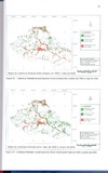
| dc.description.resumo | Este trabalho investiga a dinâmica das classes de uso e cobertura da terra na subbacia hidrográfica do Arroio Arenal RS, através da representação de processos espaço-temporais. Por meio de um conjunto de imagens multi-sensores, realizou-se a análise espacial de uma série temporal distinta entre as datas de outubro de 1995, maio de 2000 e janeiro de 2005, gerando informações representativas da paisagem e relacionando-as a diferentes aspectos sócio-econômicos, políticos e ambientais inerentes a sub-bacia em questão. A análise espacial parte da linguagem LEGAL
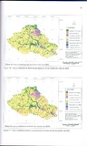
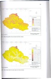
implementada em um Sistema Geográfico de Informação, que possibilitou ainda o emprego de técnicas de processamento e classificação digital de imagens e a geração de mapas temáticos, tais como base cartográfica e declividade que
complementaram a representação de cenários da área de estudo. A classificação digital das imagens de satélite foi realizada do modo supervisionado, utilizando-se o algoritmo classificador Bhattacharya, os dados gerados neste processo embasaram a análise espacial do uso e cobertura da terra, na qual foram definidos os principais parâmetros para avaliar a dinâmica da área de estudo: evolução florestal, evolução
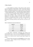
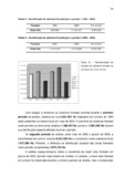
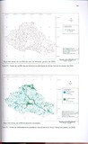
agrícola e evolução da regeneração. Entre os principais resultados, destaca-se a predominância dos campos na paisagem regional, ocupando 63,71% da área, e o grande avanço agrícola sobre estas áreas, quantificado no fim do período em 8.830,163 Ha, e ainda o acréscimo de áreas florestais em 6.276,749 Ha. A partir do mapeamento das Áreas de Preservação Permanente e dos conflitos ambientais
ocasionados pelas práticas agrícolas em locais inadequados, foram delimitados 1.719,957 Ha como sendo áreas de reflorestamento prioritário. Conclui-se que a intensidade das atividades exploratórias na sub-bacia são responsáveis por várias mudanças ocorridas durante o período analisado. | por |
| dc.contributor.advisor1 | Pereira, Rudiney Soares | |
| dc.contributor.advisor1Lattes | http://lattes.cnpq.br/9479801378014588 | por |
| dc.contributor.referee1 | Giotto, Enio | |
| dc.contributor.referee1Lattes | http://lattes.cnpq.br/0619523016722374 | por |
| dc.contributor.referee2 | Longhi, Solon Jonas | |
| dc.contributor.referee2Lattes | http://lattes.cnpq.br/2401814326298046 | por |
| dc.creator.Lattes | http://lattes.cnpq.br/7071806814420938 | por |
| dc.publisher.country | BR | por |
| dc.publisher.department | Recursos Florestais e Engenharia Florestal | por |
| dc.publisher.initials | UFSM | por |
| dc.publisher.program | Programa de Pós-Graduação em Engenharia Florestal | por |
| dc.subject.cnpq | CNPQ::CIENCIAS AGRARIAS::RECURSOS FLORESTAIS E ENGENHARIA FLORESTAL | por |